
It bugs me when journalists refer to things in China as “secretive”. Most of the time, “secretive” just means “not covered in English-language media. Typically, it’s a trick to gin up mystery around something that isn’t actually that mysterious at all, and if the journalist had taken the time - or had the ability - to research the topic with Chinese sources, they would have found that it wasn’t that secretive at all.
I preface my essay with this commentary to establish a shared understanding: when I say something in China is secretive, I really mean it. A secretive Chinese project in my eyes means it’s hard for anyone to find credible information about it, even in Chinese.
That is the case for the now under-construction hydropower mega-project on the Yarlung Tsangpo River in eastern Tibet/Xizang, also called the Medog Hydropower Station. Formally under construction since the middle of 2025, this behemoth is budgeted at ~1.2 trillion CNY ($160-170 billion USD) and expected to eventually boast 60GW of electricity generation capacity. That’s more than the current installed power generation capacity of Sweden or Argentina, and roughly 3x the generation capacity of the Three Gorges Dam, which is already the largest hydropower facility in the world. Yet for all the fanfare about the project’s ambitious scale, the public knows very little about what kind of facility it even is, never mind details like the construction milestones, power export destinations, effects on the surrounding environment, or expected impact on human populations.
Although information transparency is never going to be the Chinese government’s strongest suit, it’s still uncommon for the public to lack even basic details about the engineering concept for a project like this. Will there be a dam? How high will it be? Where will it be? Is there a reservoir? How large will THAT be? Even today, these seemingly mundane details about the Yarlung Tsangpo project aren’t publicly stated anywhere, contrasting even with the history of other large hydropower projects in China. Understandably, the lack of information has also created worries among China’s neighbors.
Natural abhors a vacuum, and this applies to information too. In the absence of transparency, conspiracy theories and insinuations swirl. Unfortunately, rarely is the information that fills voids of particularly high quality. With Himalayan mountains and insinuations about Chinese infrastructure development plastered all over the news thanks to the recent mudslide/flooding tragedy at the Nepal/Tibet border, despite being 1000+ km away, I suppose it’s as good a time as any to assemble all currently known or inferable information about the Yarlung Tsangpo hydropower project, in English, in to one place, in FAQ format. I’m not typically much of an OSINT guy, but I do like big infrastructure projects, so I decided to make an exception this time.
I envision this as being a kind of long-term project, with this essay updated as often as there’s new, interesting information to share, but we’ll see how committed I’ll be.
A Note on Methodology
Because the engineering specifications of the Yarlung Tsangpo project have not been publicly released, the geographic and topographic estimates in this essay are derived from independent analysis and OSINT methods. I used Google Earth imagery, Copernicus terrain and elevation data, Chinese planning documents, procurement records, local government reports, and publicly available village and infrastructure databases to estimate the elevations of settlements, transportation corridors, river reaches, and potential reservoir extents. Where official information exists, I generally treat it as authoritative. Where it does not, I distinguish as clearly as possible between directly observed facts, informed inferences, and speculation.
What is the Yarlung Tsangpo?
The Yarlung Tsangpo is the 8th-longest river in China, the highest major river in the world, and the longest in Tibet. Its headwaters arise from the Angsi Glacier on the Ganglung Kangri Mountain, not far from Mt. Kailash. It flows steadily east for 2000km, growing in size along the way, before making a sudden change in direction to navigate around Namcha Barwa Peak and head south, where it crosses the Himalayas, leaves China and enters India’s Arunchal Pradesh state.
In Arunchal Pradesh, it is briefly called the Siang River before it enters Assam state, where it picks up its most well-known name, the Brahmaputra. From there, it crosses northeastern India in a southwesterly direction and enters Bangladesh, where it becomes the Jamuna River and again turns south. Shortly thereafter, it merges with the Ganges (aka Padma) east of Dhaka and then the Meghna River, before draining into the Bay of Bengal, ~2900 km downstream from the Angsi Glacier.
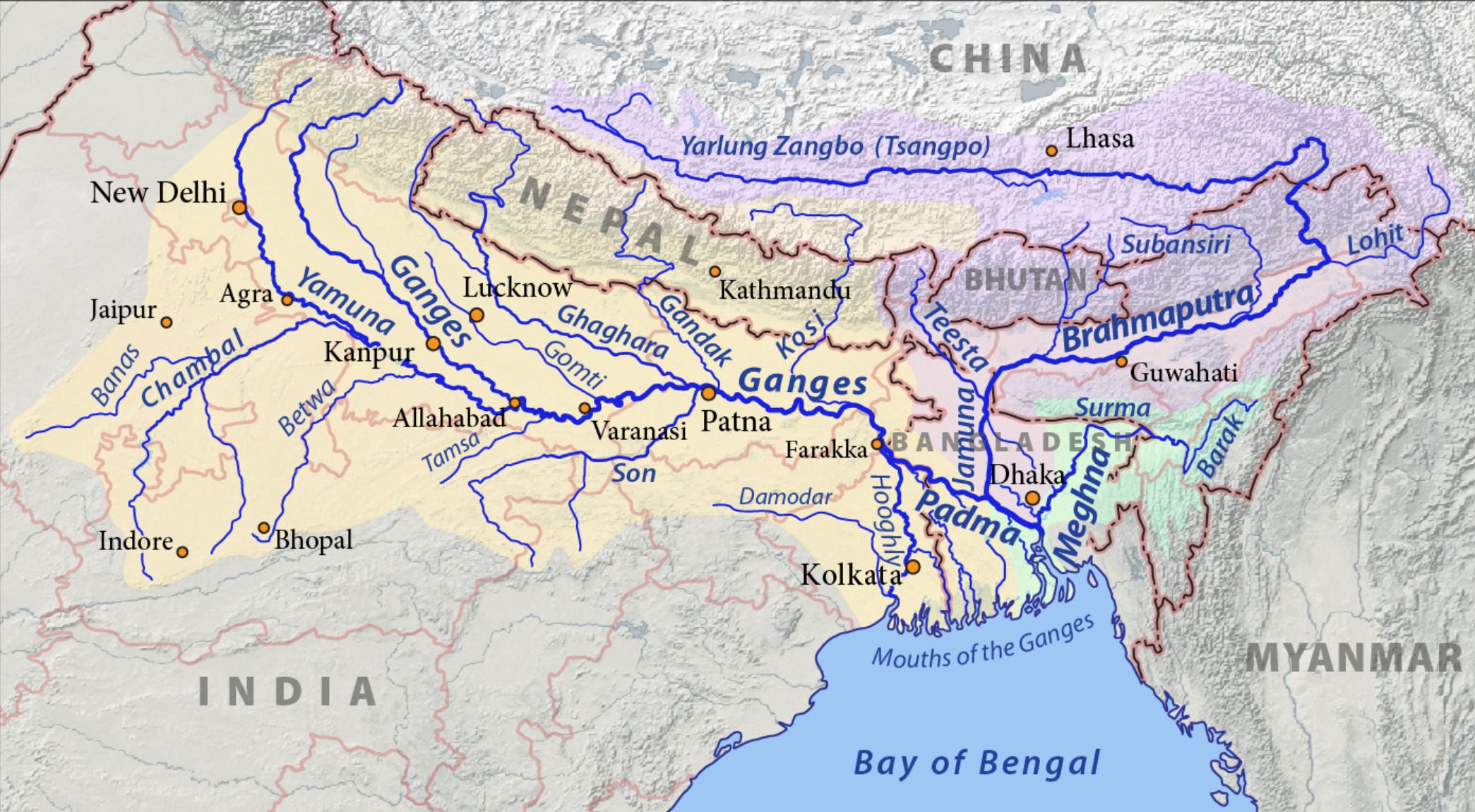
In the Tibetan language, Tsangpo means “great river” and Yarlung is a reference to the Yarlung Valley, regarded as the cradle of Tibetan civilization.
The Mandarin Chinese name is 雅鲁藏布, or “yalu zangbu”, a transliteration of the Tibetan name. For clarity, the word for “river” (江) is usually affixed to the end of the name, since the typical Chinese speaker wouldn’t recognize zangbu already means river, so they end up calling it the Yarlung River River (this happens all the time with river and mountain name translations across languages). It’s often shortened to just 雅江 (Ya River) in colloquial speech.
Where is the Hydropower Project?
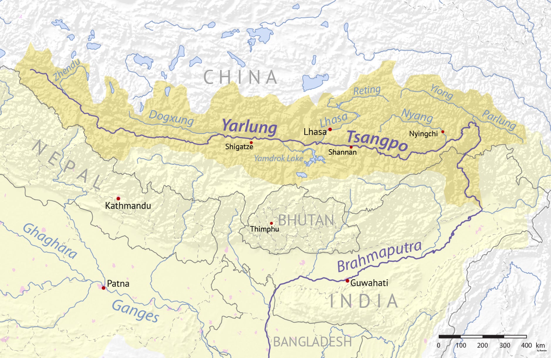
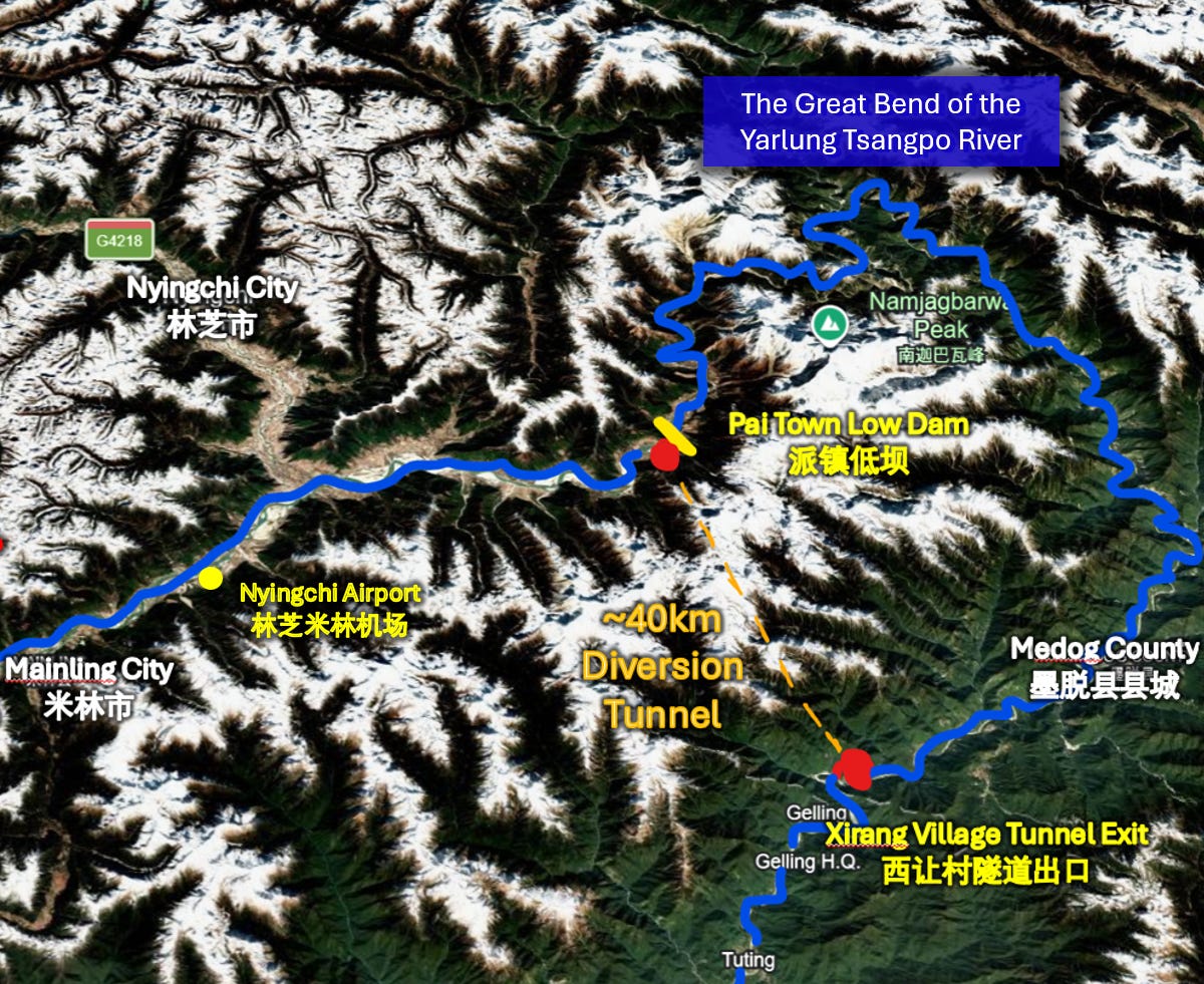
There are several small-to-medium hydropower projects further upstream on the Yarlung Tsangpo, but the one that we really care about is quite far downstream on the eastern stretch of the river where it does that big loop (the Great Bend) around Namcha Barwa Peak (南迦巴瓦峰) and then heads south.
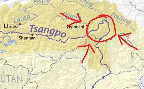
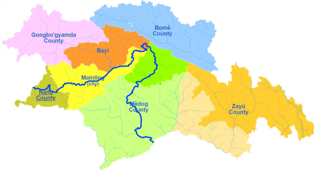
Administratively, this area is part of Tibet’s Nyingchi (林芝) Prefecture, with its prefecture seat indicated by a small dot on the map above.
That dot also corresponds to Bayi District on the map below. I’ve traced out the Yarlung in blue, showing how it enters Nyingchi in Nang County, threads its way through the center of the administrative area of Mainling City (米林市) in a east-northeast direction and then makes that big loop down into Medog County (墨脱县) and eventually India.
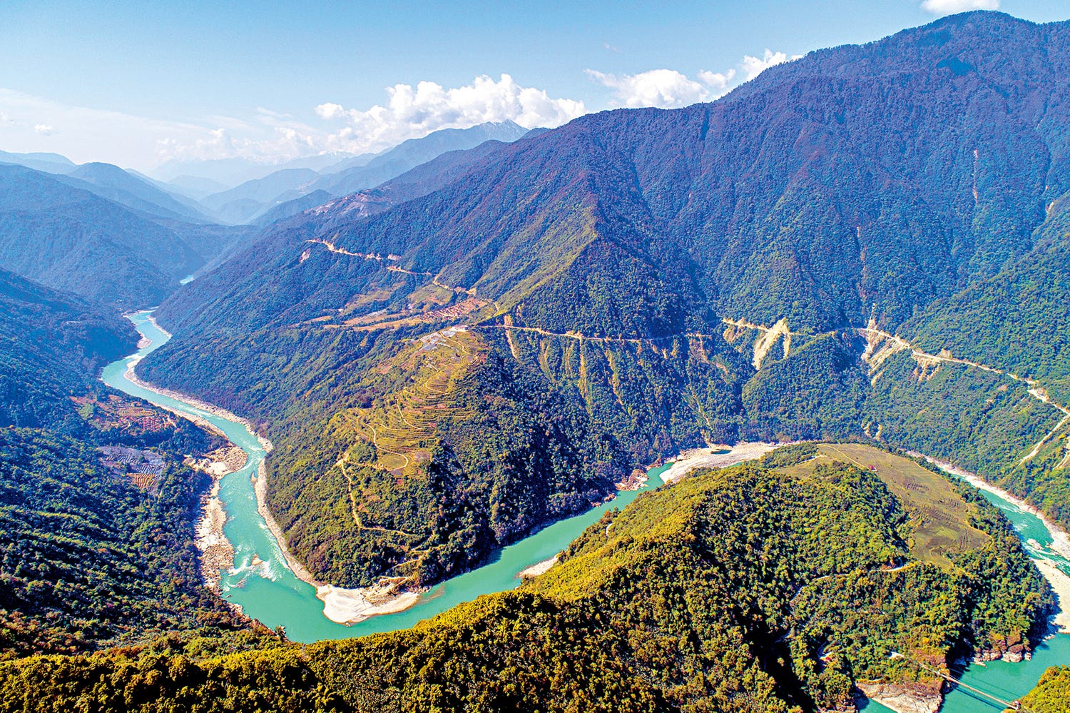
Don’t be misled by the existence of “districts”, “counties”, and “cities” here. This region is extremely remote, which you can tell clearly from the satellite view. Actually, it’s essentially all mountains and glaciers, with most of the area surrounding the mountain being pristine alpine wilderness.
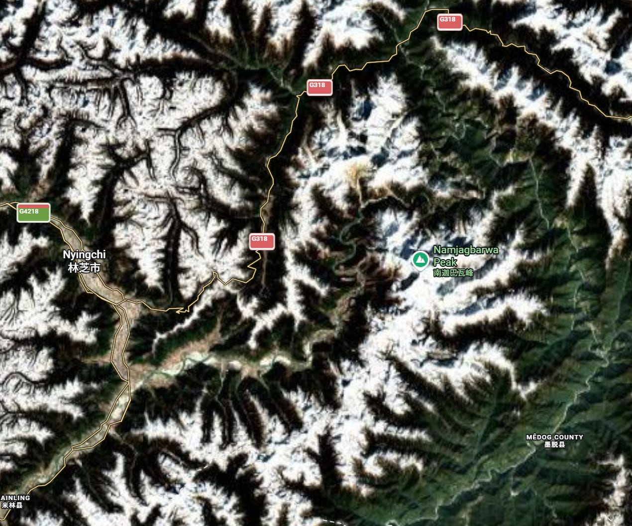
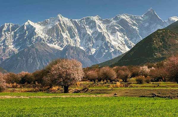
The Great Bend of the Yarlung Tsangpo circumnavigates the 7,782m Namcha Barwa Peak (labeled Namjagbarwa Peak on the map), the 27th-tallest mountain in the world. From 1967-1992, it was the tallest unclimbed mountain the world. Since its first ascent by a joint Sino-Japanese team, it retains the distinction of being the tallest peak to only have been summitted once. It is the tallest of the east Himalayas, the third most-prominent, and the world’s easternmost 7000m+ peak.
As the river meanders on its ~200km sightseeing loop around the mountain’s ravines, it does something very interesting: it loses more than two kilometers of of vertical elevation. By the time it reaches the bottom of the Great Bend, it has succeeded in crossing the Himalayas, descending from an elevation of ~2950m in Mainling City to just 600m in Medog County.
This 2350m drop between the upper and lower segments of the river’s great bend around the mountain is the basis of the the concept design for the hydropower facility. Hydraulic engineers know what a river’s huge elevation loss over a short distance means: a lot of potential energy to be harnessed by a hydroelectric facility.
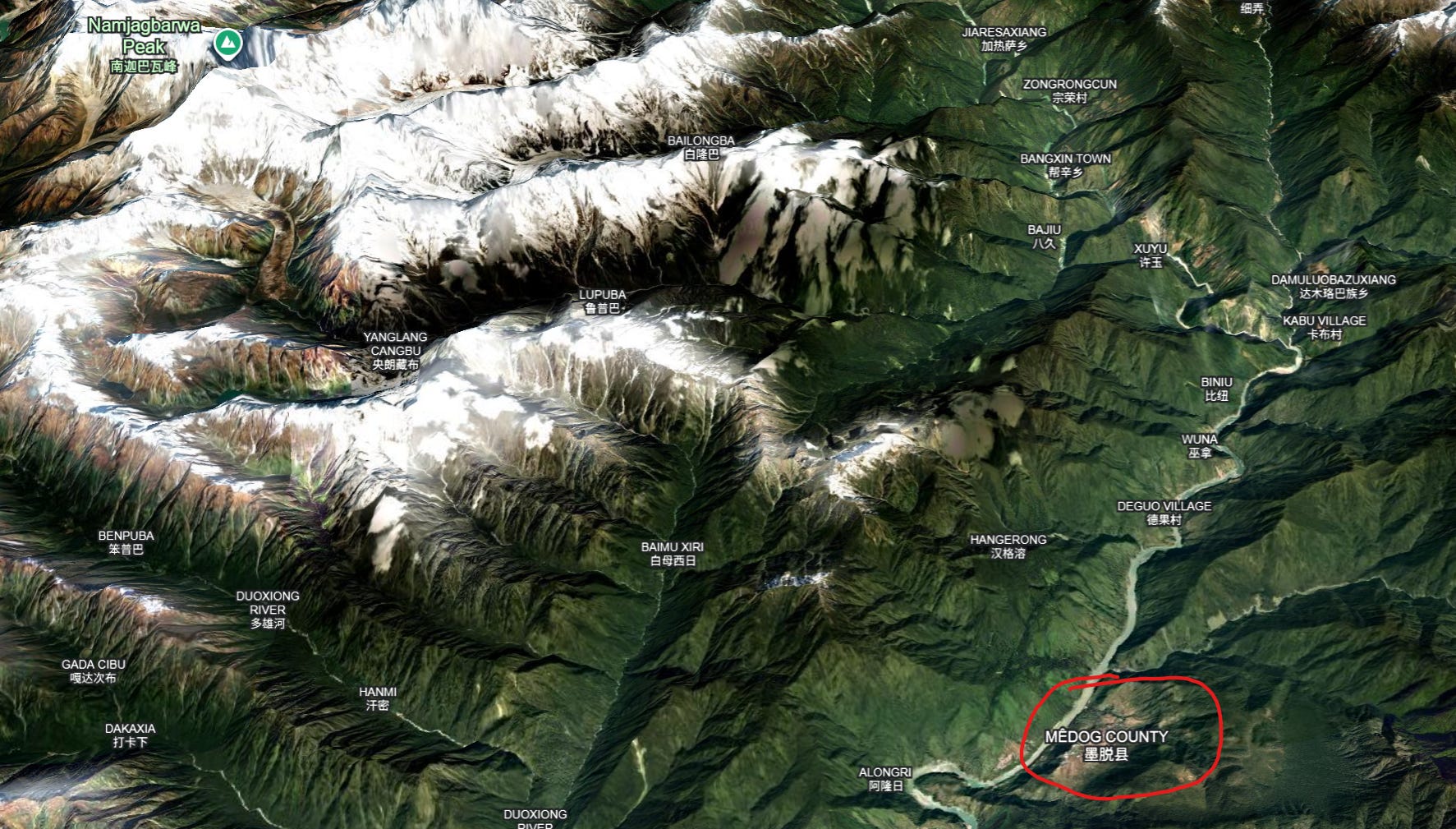
Side note: With a population of just 15,000, Medog is Tibet’s only inhabited region south of the Himalayas. Its low altitude allows it to enjoy a humid subtropical climate unlike anywhere else in Tibet, with rainforests and tropical fruit. Medog was the very last county in China to be connected to the national road system, with its highway to Bome County only completed in 2013 after 52 years of intermittent construction, and described on Wikipedia as “a modern engineering marvel that traverses six active fault zones in the eastern Himalayas”.
Today, Medog is now also connected to Nyingchi via a spur of National Highway G219 that bores through the mountain, completed in 2021. Sadly, I don’t know if I’ll ever be able to visit, as it is completely closed to foreign tourists, even with a Tibet Travel Permit, due to its sensitivity as a border region with India.
What Kind of Hydropower Project is It?
Officially, the Medog Hydropower Plant is a “run-of-river water diversion” facility. The project will bore a long underground tunnel as a headrace between the upper section of the Great Bend, near Mainling City’s Pai Town (派镇) at 2950 meters, and the lower section of the Great Bend, with Medog County’s Xirang Village (西让村) at ~600 meters.
Water from the river at the top of the great bend will be diverted into the ~40km tunnel, where it will flow downhill at a continuous grade of ~5-6%. This will produce an enormous hydraulic head, sufficient to drive five separate powerhouses along the way, each one at ~12GW, for a total of 60GW. At the bottom of the tunnel, the water will rejoin the original course of the river. Chinese planners have described this approach as “zero net consumption of water”, with all water diverted at Pai Town returned to the river’s course at Xirang Village before it flows into India.
This tunnel diversion concept is not new. Hydropower engineers have employed similar principles since the earliest generating schemes at Niagara Falls more than a century ago, diverting water through artificial channels to take advantage of elevation differences before returning it to the river. China itself has already demonstrated a modern version of this approach at the Jinping II hydropower project on the Yalong River, which uses a 16km tunnel to bypass 150km of the Yalong River’s natural course. What makes the Yarlung Tsangpo project remarkable is the unprecedented scale.
When the project is completed (est. 2033), the generated power will feed into a network of UHVDC lines and transmitted across the country. As of 2026, one dedicated export corridor is already clearly identified: the 800kV Tibet-Greater Bay Area UHVDC line, rated at 10 GW. However, this line alone can only transmit a fraction of the project’s expected annual output of ~300 TWh. Additional UHVDC export corridors will certainly be required, but are not yet known.
Crucially, the water diversion scheme in Pai town will NOT use a high dam. It can’t be a high dam, because there’s no room for a reservoir behind it. From the image above, you can see Nyingchi’s main airport in Mainling City lies just 30km upstream on the riverside only ~20-30m above the water level. There’s only a 10m elevation drop between the river bed at the airport and at Pai Town and the airport only has a small clearance over the river, so any reservoir deeper than 20m or so would endanger the airport.
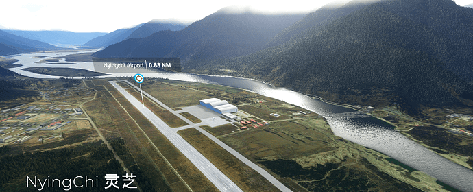
Local media in Mainling City mention a “low dam” (低坝) at the Pai Town site, with “backwater extending to the airport”. This updates earlier thinking on this structure, when there was confusion about whether it would be an actual dam blocking the river, or more like a weir to direct the water into the diversion tunnel. It is now confirmed to be an actual dam - a small one, with a small reservoir, suitable for hourly and daily regulation of the water supply to the hydroelectric facility.
But if there’s no large dam, and no large reservoir, how can the project possibly serve as a stable and reliable producer of electricity on an annual basis across seasons? A 20m reservoir created by a small dam isn’t going to get you far.
That’s where one of the biggest confusions of this project arises. Because there IS a high dam for this project; it’s just not at Pai Town.
Where’s the Damn Dam?
This has been the point of greatest confusion - whether the Medog Hydropower Plant will have a high dam, what kind, how tall, and where it will be. Nearly every Chinese online post about dam structures for this project over the last 2 years has dissolved into arguments and name-calling over this point. Fortunately for you, my reader, out of all the people spending hours of their lives researching and debating this topic, I have the least regard for for the value of an hour. And thus, I can present to you the most accurate up-to-date perspective on the question of this damn dam.
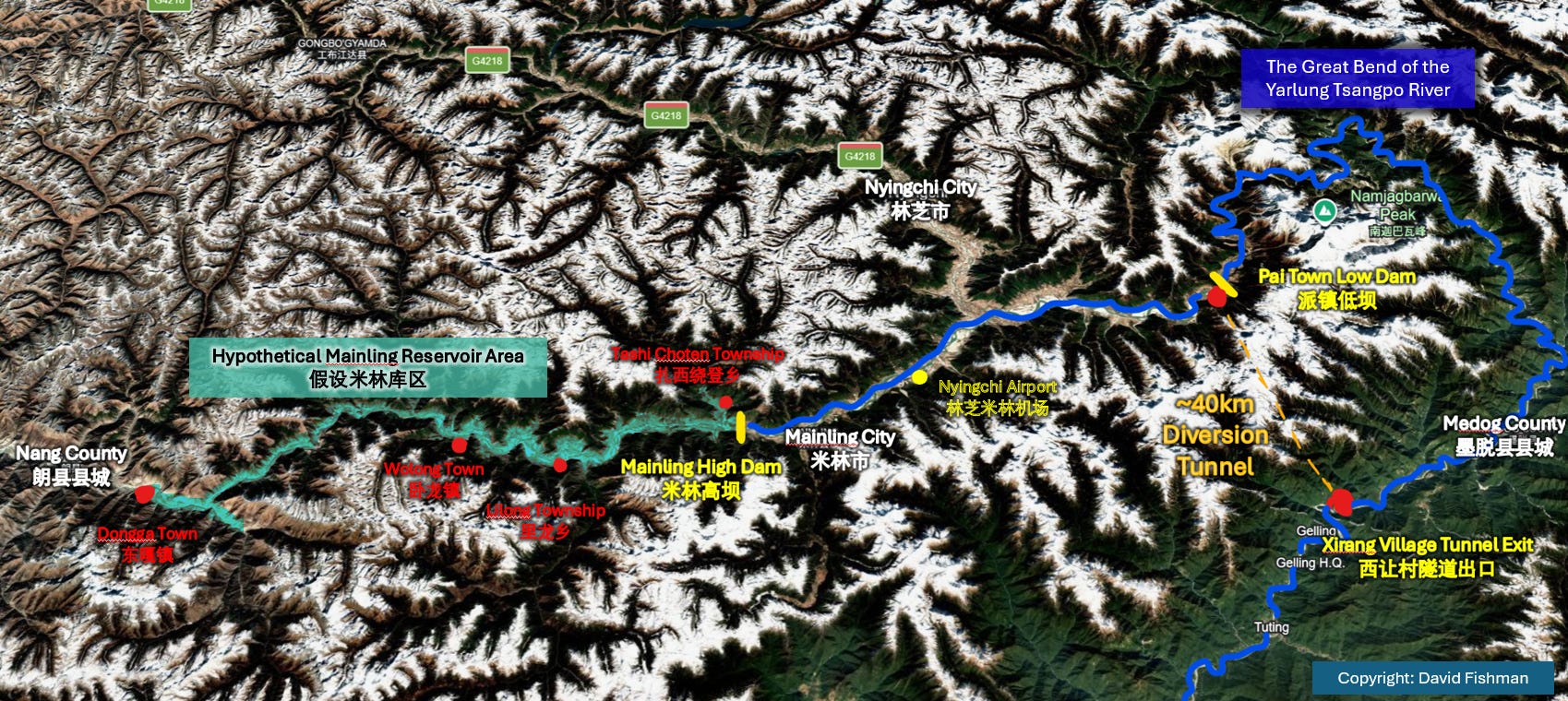
The high dam associated with the Medog Hydropower plant will be located over 100km upstream to the west of Pai Town, past the airport and even Mainling City itself, in Yusong Village (玉松村) of Lilong Township (里龙乡).
Lilong Township is administered by Mainling City, and so this dam will be called the Mainling Dam (米林大坝) or the Milin Dam, if using the Chinese name for the city. I will use Mainling Dam for this essay, although the names are interchangeable.
The annotated map below illustrates the relative location of the Mainling high dam, the low dam/tunnel intake point at Pai Town, and the exit point at Xirang Village on the other side of the Great Bend.
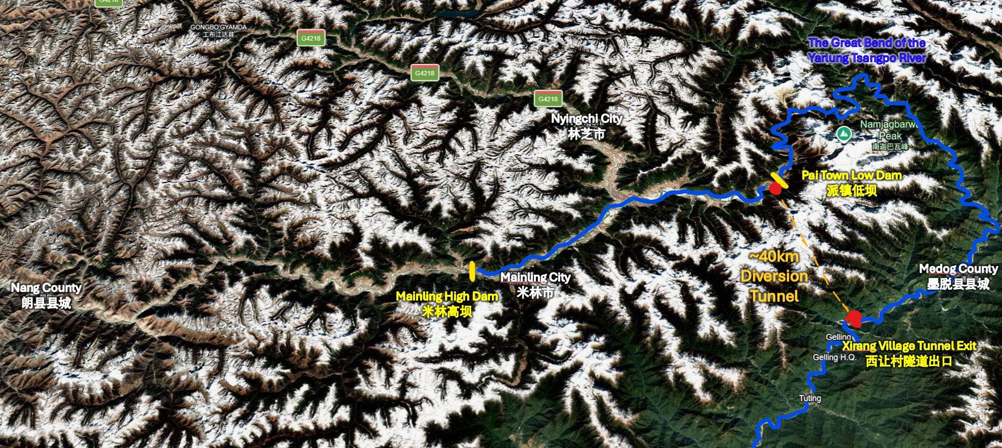
This location appears to have been chosen for a high dam because it offers more space for upstream backwater accumulation without submerging larger settlements. While there are a few small towns and villages along the river further west upstream of Yusong Village, there’s certainly nothing as critical as an airport.
This location for the dam is aligned with the best piece of official evidence we have: a CCTV Xinwen Lianbo broadcast from August 2025 covering the official launch ceremony for the construction project, which was held near the dam's planned construction site and attended by then-Premier Li Keqiang.
In the image below, taken by Zhihu user 梵华, an arrow in the center of the image points to the site of the dam, indicated to be immediately after a point where a tributary joins the Yarlung Tsangpo.
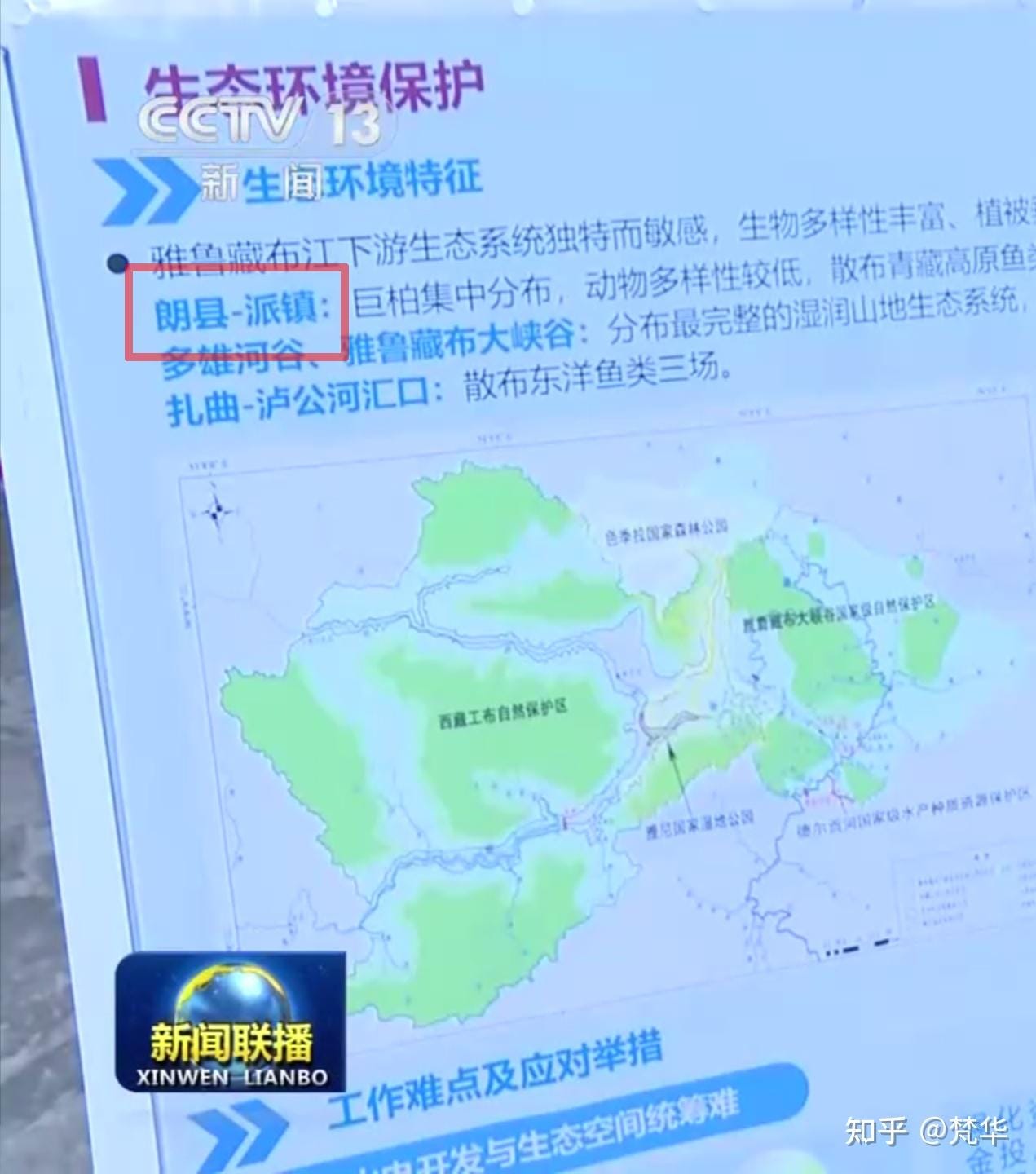
In reality, this tributary isn’t a permanent river so much as a small stream coming down the ravine, carrying seasonal glacial melt. It’s not even named on maps. This is more apparent when looking at a Google Earth close-up of this location.
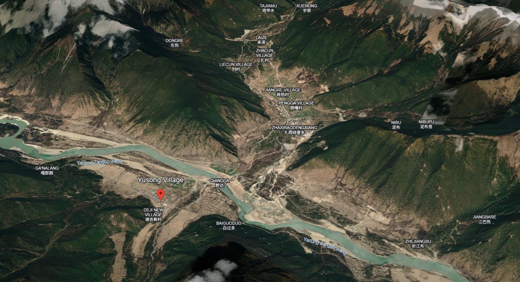
From both the satellite view and the August 2025 Xinwen Lianbo broadcast, we can see the land next to the river is fairly flat here. The launch ceremony appeared to take place directly in the riverside fields of Yusong Village, just across from where the small stream emerges from the ravine and enters the river, as Zhihu user 梵华 identified below by cross-matching the broadcast view to satellite images:
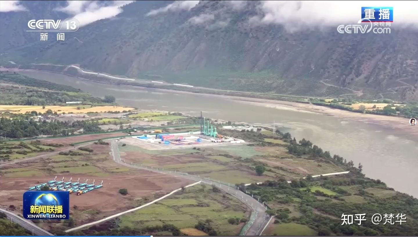
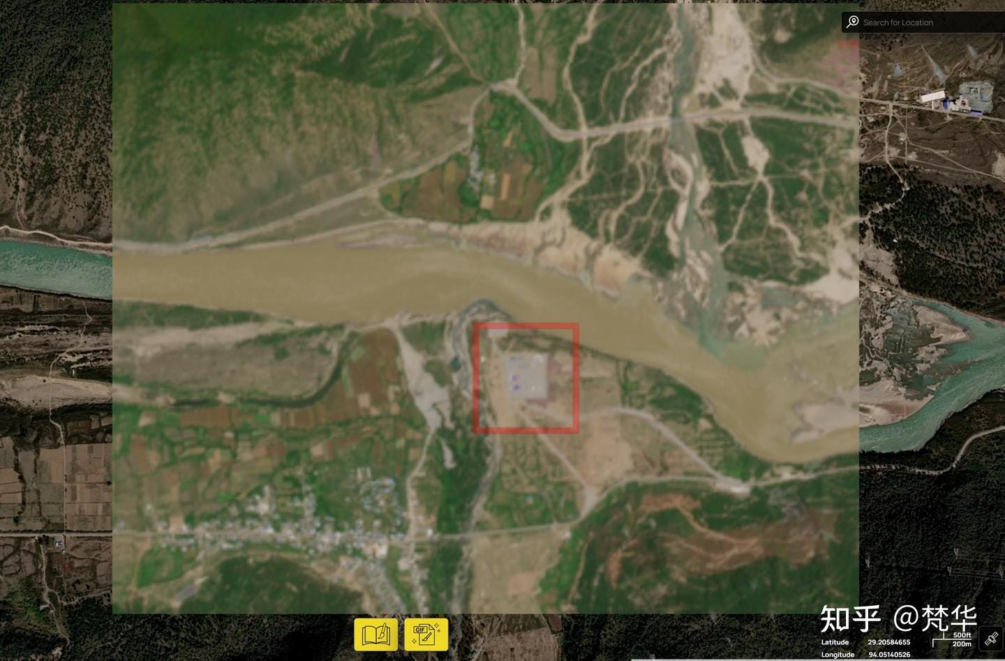
According to these images, the actual location of the dam would be immediately after the confluence, with the reservoir stretching back up the main channel of the river, as well as the side ravine. This is my speculation here, of course but perhaps it would look something like this:
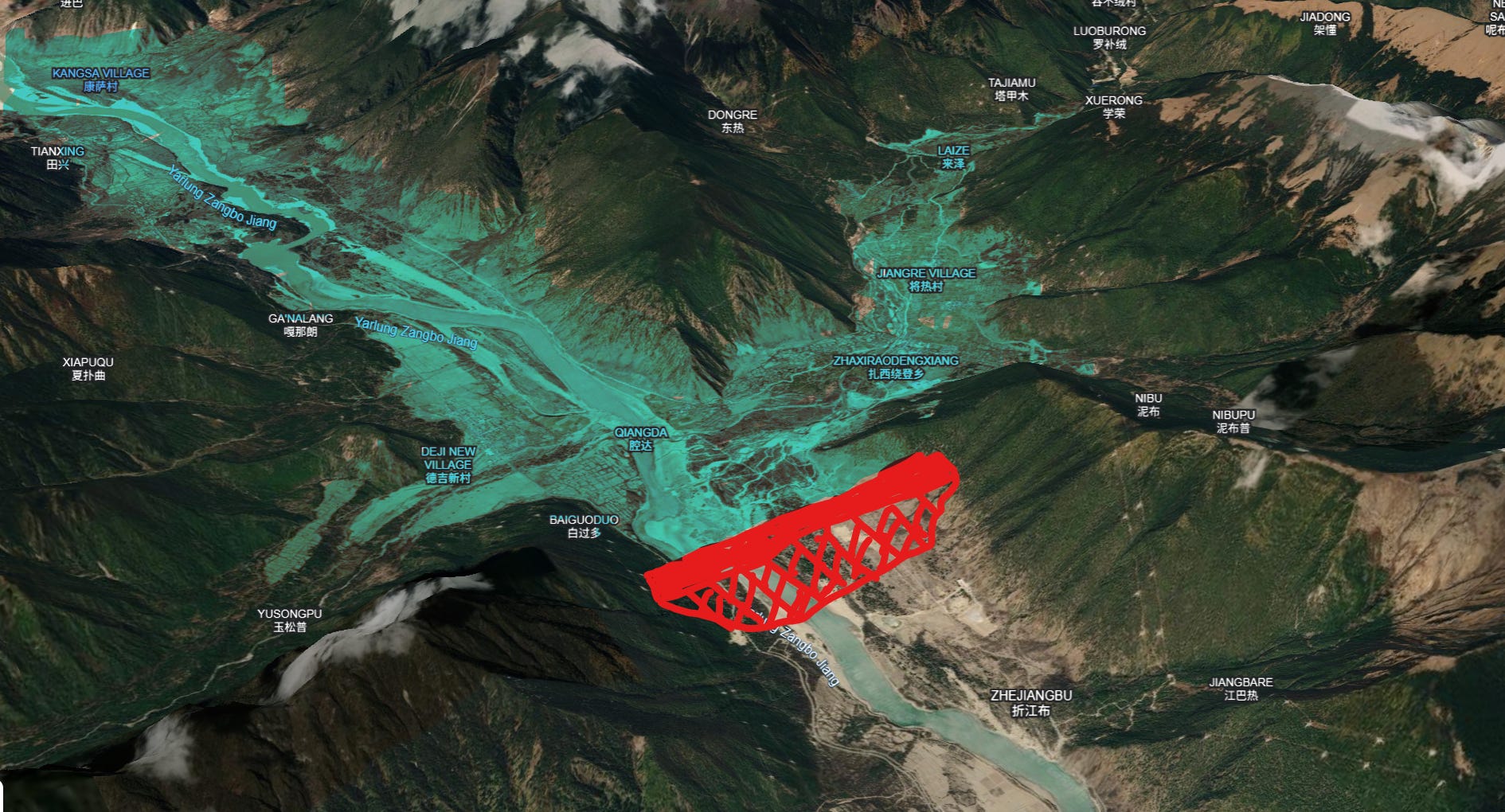
In the image, I’ve drawn my speculated location for the dam in red and illustrated in blue-green where the reservoir’s backwater would begin, inundating both the Yarlung Tsangpo’s valley to the west, as well as the ravine to the north.
If my assumptions are correct, then the first settlements that will be submerged behind the reservoir are Deji New Village and Yusong Village on the south bank, and Tashi Rabten Township (扎西绕登乡) on the north bank. Any smaller villages along the banks of the river upstream will also be inundated.
So, How Large is the Dam?
The Mainling dam's precise technical parameters like crest elevation, normal pool level, and reservoir depth have not been officially disclosed. This is where things get tricky, and where my view differs from Chinese OSINT analysis.
The height of the dam determines the normal water level of the reservoir, as well as how far upstream will be inundated. Here, Chinese netizens have identified at least one hard constraint: the Lhasa-Nyingchi railway, which makes its way through the mountains north of the river at an altitude of 3070m. Also, recent procurement records for road construction in the area have indicated that the roads must go no lower than 3070m, seemingly a floor level related to the hydropower project. I agree with these figures as the peak possible height for the reservoir.
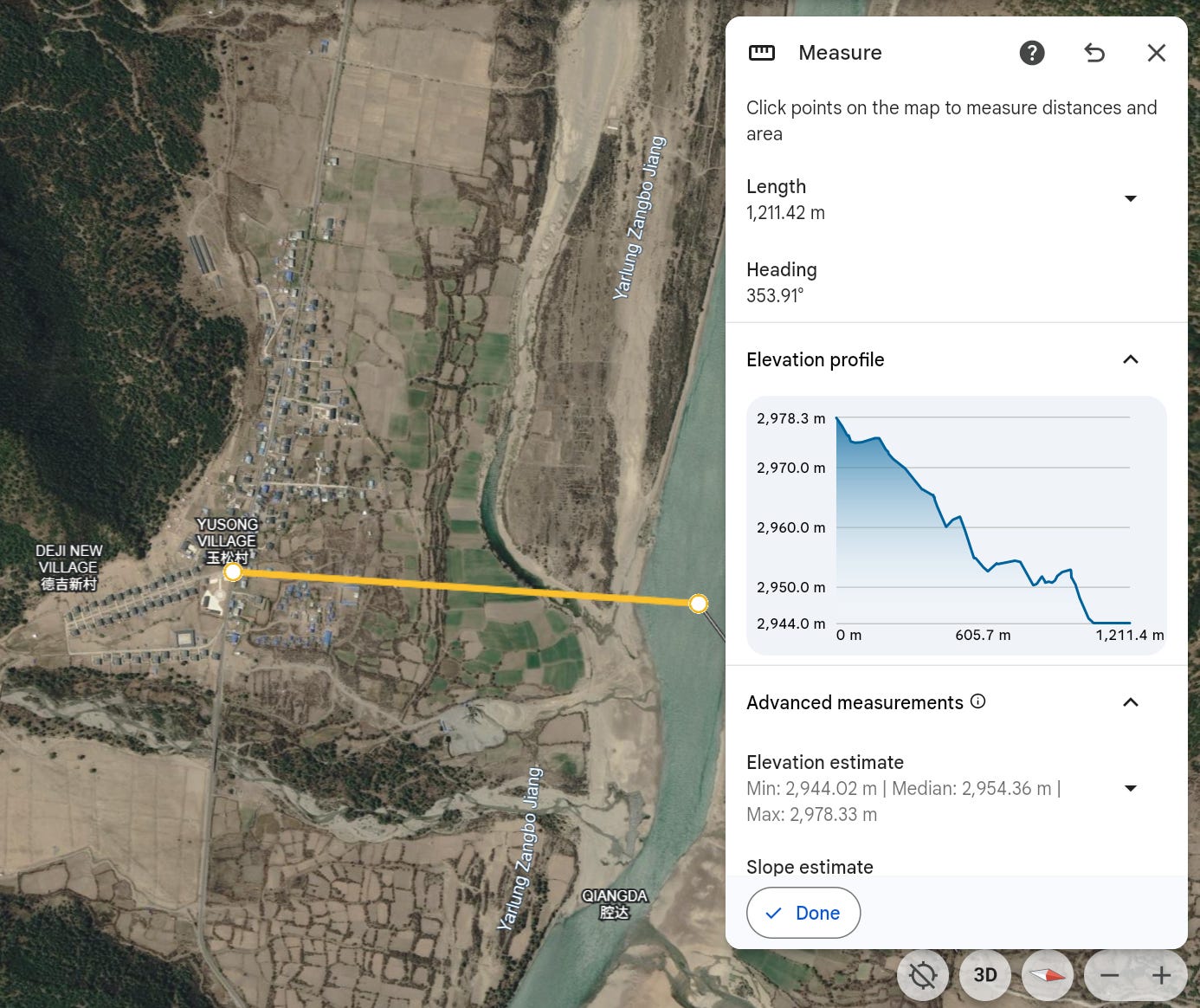
The river’s water level at Yusong Village is ~2944m according to Google Earth satellite data, which would give the dam’s designers ~130 meters of reservoir depth to work with (putting aside that there’s a margin of error with satellite elevation data in mountainous regions that we just have to accept and work with). Chinese OSINT users thus assumed the Mainling Reservoir would be 130m at its deepest point, with the dam crest ~150m high.
I think these OSINT assumptions have some problems. To stress-test them, I introduce an additional source of evidence that earlier analyses either did not consider or did not yet have: local resettlement records. For several years now, well before the official construction launch, local officials have been working to relocate villages that will eventually be submerged by the reservoir, and they usually make a point of celebrating when resettlement work has completed. Local media also likes to document when officials visit the resettlement zones to inspect and oversee work.
So, I searched local government and state media reporting for references to reservoir migrants, completed village relocations, new settlement sites and replacement town centers. I then compared that paper trail against the potential inundation zones indicated by the terrain data to determine the likely upstream extent of the planned reservoir.
This method requires some caution. Not every relocation in this part of Tibet is connected to hydropower. The region also has poverty alleviation resettlements, high-altitude village improvement projects and newly constructed border settlements. I therefore only treated relocation as evidence of reservoir inundation where official reporting identified the residents as reservoir migrants, or where the relocation was mentioned together with new settlement and township construction for “a major national project”.
My evidence trail:
First, the administrative center of Tashi Rabten Township just north of the planned dam is clearly moving. As early as July 2025, Tibet’s Party secretary inspected the new “Tashi Rabten town construction site”, where officials briefed him on its overall planning, infrastructure and supporting facilities. The visit was explicitly framed as settlement construction in service of a “national major national project”.
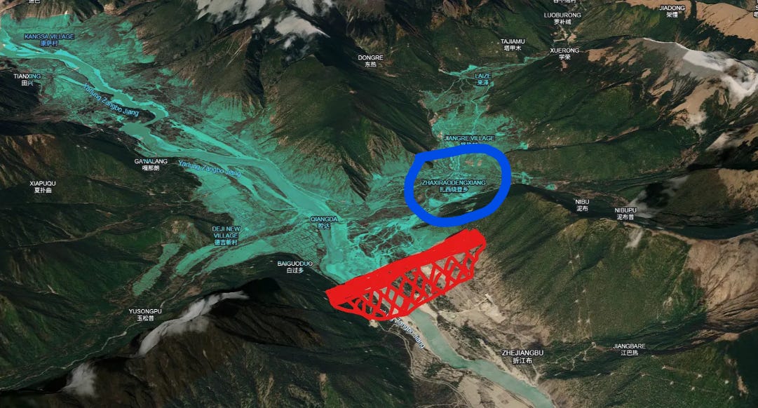
Furthermore, in June 2026, the Tashi Rabten government announced that it was vacating its existing premises and temporarily moving its government offices and public service center to Milin City. State media has also reported on the successful relocation of Kangsa Village (康萨村) and Senbo Village (森波村) upstream on the north bank, both part of Tashi Rabten.
We also have good evidence for the relocation of Lilong Township (里龙乡) further upstream. This emerged in April 2026, when a local government Wechat account covered Milin Party Secretary Yan Shihui’s inspection of the “new Lilong township site”. The report noted the need to “carefully and patiently” manage work with “relocated residents” and described a visit to the “resettlement site of Deji New Village”, including temporary housing and a kindergarten, strongly suggesting that relocation of at least part of the existing Lilong Township is already underway.
From these clues, we know the reservoir will at least stretch upstream to the point where it will inundate the Lilong Township seat.
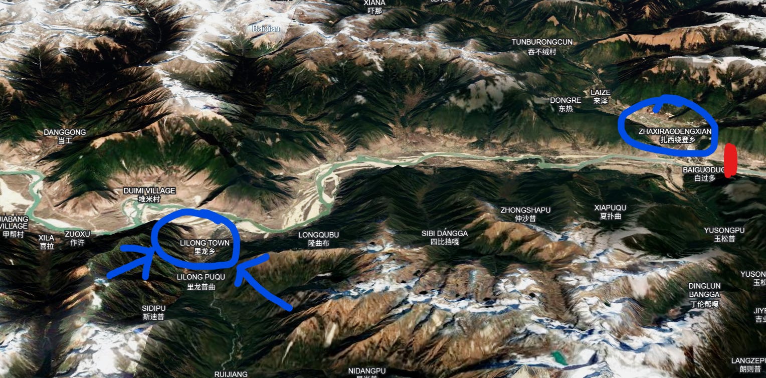
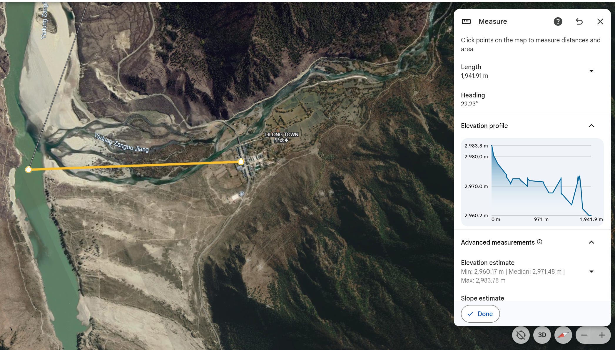
In the satellite view below, which is oriented facing east, we can see the current seat of Lilong Township at 2983m is just ~23 meters higher than the river’s level at 2960m. This area will undoubtedly be underwater. Notably, some of Lilong Township’s constituent villages on the cliffsides of the south bank sit much higher than this, and may be unaffected by the reservoir.
The really crucial evidence comes at the next town along, about 45km upstream from the hypothetical dam site. This next town is Wolong Town (卧龙镇), the last town belonging to Mainling City heading west before entering Nang County.
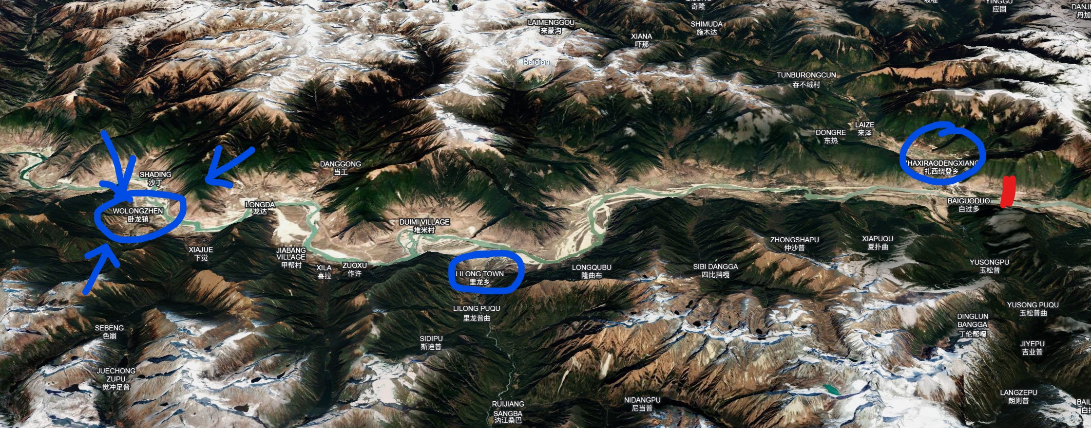
There’s currently no indication that Wolong Town is preparing to be submerged.
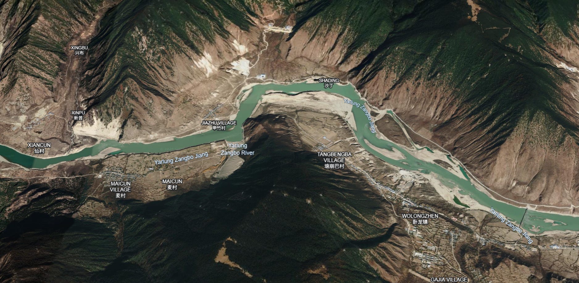
Perched on cliffs high above the river below, Wolong sits at a lofty 3050-3080m of elevation, some ~80-110m above the river’s level at 2970m. Moving upstream from Lilong, the riverside terrain gains elevation quite rapidly, while the elevation of the river itself rises much more slowly, forming a dramatic gorge.
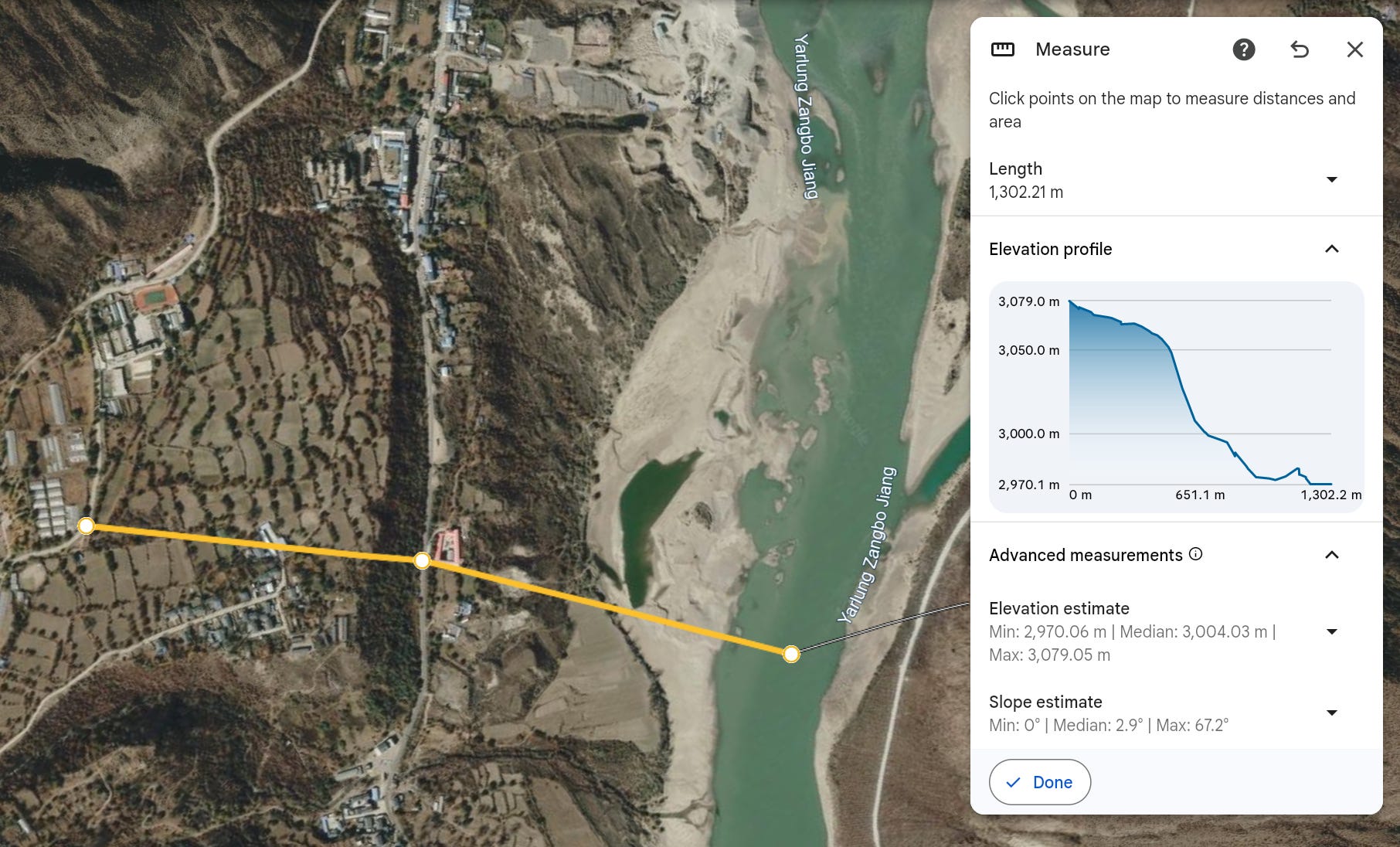
Now, not only does Wolong Town show no signs of being resettled, but there are even news reports and procurement documents saying Maicun Village (麦村村) in Wolong has been identified as a potential site for a new resettlement community related to the construction of the hydropower station. In 2024, project tenders were issued for geological hazard assessments relating to the proposed Maicun resettlement, including for rockfalls coming from the steep mountainous gully located directly above the proposed site in Maicun.
These documents suggest that Maicun is being evaluated as a location to receive relocated populations, NOT slated for relocation itself. However, the documents do not specify where the residents assigned to this settlement will come from.
Maicun Village broadly sits between 3100m and 3000m, with the highest point on the terraced fields behind the village rising to 3140m.
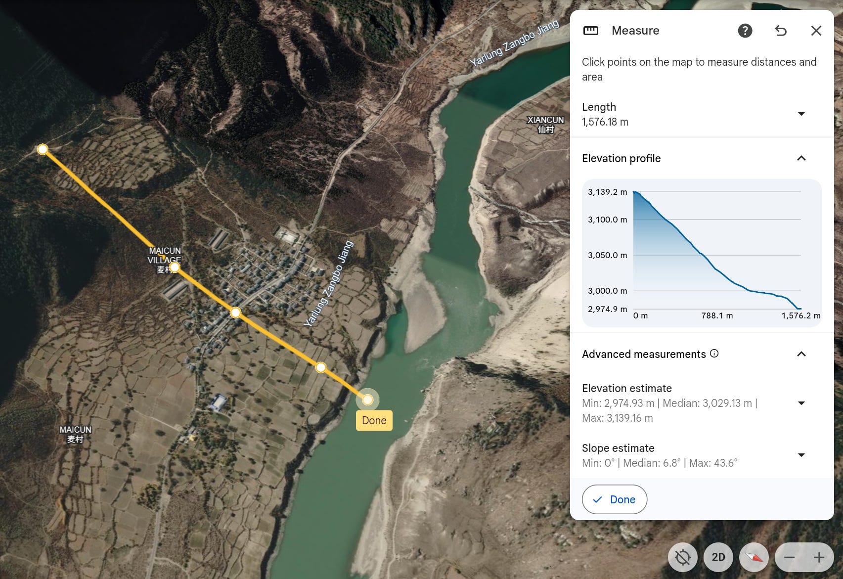
So, if the Wolong Town seat at 3050m shows no signs of being relocated, and Maicun Village at 3000-3100m is being considered as a resettlement destination, we have a fairly revealing indicator for the maximum height reservoir is expected to reach, and it seems to be be a good bit lower than what was believed previously.
Contrasting the earlier conclusions of the Chinese OSINT writers, the normal water level of the reservoir cannot be as high as 3070m, else Wolong at 3050m would be submerged and Maicun would be unsuitable as a resettlement destination. This still doesn’t give us a definitive reservoir level, but if we use Wolong as the limit and assume a 10m safety margin, then it would imply the reservoir level can rise to no more than ~3040m. Based on the river level at the dam site sitting at 2970m, this implies a maximum reservoir depth ~70m, and thus a dam height in the range of 90-120m, significantly lower than the 150m figure circulating in OSINT analyses.
Of course, even if Wolong Town is safe on its cliffside, the reservoir will still continue on quite a ways further upstream until the elevation of the river bed itself meets the normal reservoir height. The next county over - Nang County - notes on its government page that the lowest point in the county is the river surface at its border with Mainling City at 3016m, indicating the reservoir must extend into Nang County too. If we assume the reservoir’s normal water level is 3040m, then it will not meet the elevation of the riverbed until another 70km upstream from Wolong, in Nang County’s Dongga Town (东嘎镇). Many smaller villages upstream along the river banks between Wolong and Dongga that are not perched safely on a cliff like Wolong Town will likely also be submerged.
This is all reflected on my map below, which marks the locations of the affected towns and townships, along with the hypothetical reservoir area in blue-green. I have not marked the extent of the other reservoir created by the low dam at Pai Town as it will seemingly be quite modest, but will apparently stretch back to the airport.
How Many People Will be Displaced?
There’s not yet any official estimate from government authorities on how many people will need to be resettled or relocated. However, the number will necessarily be much lower than a project like the Three Gorges Dam, which saw 1.3 million people displaced by the massive reservoir that formed in the densely-populated regions behind the dam. In Tibet, the populations are much smaller and much more dispersed.
According to records from local gazetteers, Tashi Rabten has a total population of just 3552 people. Lilong has another 2038, and Wolong has 4258. Meanwhile, Dongga Town has just 2489. There’s also likely to be some displacement downstream in Pai Town to make way for the dam structures in that area, although that’s distinct from reservoir inundation. But even if EVERY person in each of the affected townships had to be resettled to make way for the project, the entire resettlement effort would be on the order of 12-15k people. That’s likely a high estimate, since some of those villages far above the riverbed (like the seat of Wolong Town itself) will not be displaced at all. Certainly a very different situation from the Three Gorges Dam.
In addition to settlements, the project will also affect agricultural land. In some cases, a village may not require full resettlement, but part of its land must be requisitioned, such as riverside terraces or cropland located near the future reservoir shoreline. In 2024, Milin City published a schedule of compensation rates for agricultural land requisitioned by the state.
The document itself is a general compensation schedule and does not explicitly connect the villages to the hydropower project. However, it’s likely no coincidence that virtually all the villages identified in the schedule are located along the river corridor, near either the Pai low dam or the Mainling high dam reservoir. Back in October 2025, Milin media platform cited Tashi Rabten Township head Awang Banjiu saying that resettlement compensation funds of 400+ million CNY had already been fully disbursed, which covered both the hydropower project as well as legacy compensation issues from railway construction.
What are the Biodiversity and Ecology Concerns?
Both the high dam and the low dam will be subject to mandatory “minimum ecological flow” for water release targets, which are defined at the national level. For hydropower projects in China, this minimum flow level is typically set at “not less than 10% of the river’s average flow”, although it can vary by province. For the Pai low dam, the implication is that once the mandatory 10% ecological release is satisfied, the remaining 90% of the river’s flow is, in principle, available to be directed into the diversion tunnel. This will make the Pai-to-Medog stretch of the river (i.e. the Great Bend section) a greatly reduced flow, although not an entirely dry one. The flow in this section will also be supplemented by convergence with other rivers and streams along the way, including the Parlung Tsangpo (帕隆藏布), the Yarlung Tsangpo’s largest tributary.
This same stretch of the Great Bend is within the Yarlung Tsangpo Grand Canyon National Nature Reserve, the only place on Earth to host four big cat species (Bengal tiger, snow leopard, clouded leopard, and leopard) in a single river valley. It is also home to China’s only confirmed wild Bengal tiger population, which were only captured on camera in this area for the first time in 2019.

What the proposed reduction of the river to ~10% of its natural flow could mean for these cats is a matter of ecological inference. The reduced-flow sections of the river overlap with the mid-elevation forest belt that ecological surveys show is exactly the habitat of the big cats, including golden cats and the extremely elusive clouded leopard. A major reduction in flow could alter the microclimate, reducing the clustering of prey and degrading the dense forest cover these species depend on. Whether the mandatory ecological release will be sufficient to maintain the canyon's habitat’s integrity is unclear, at least publicly, as the EIA has not been released.
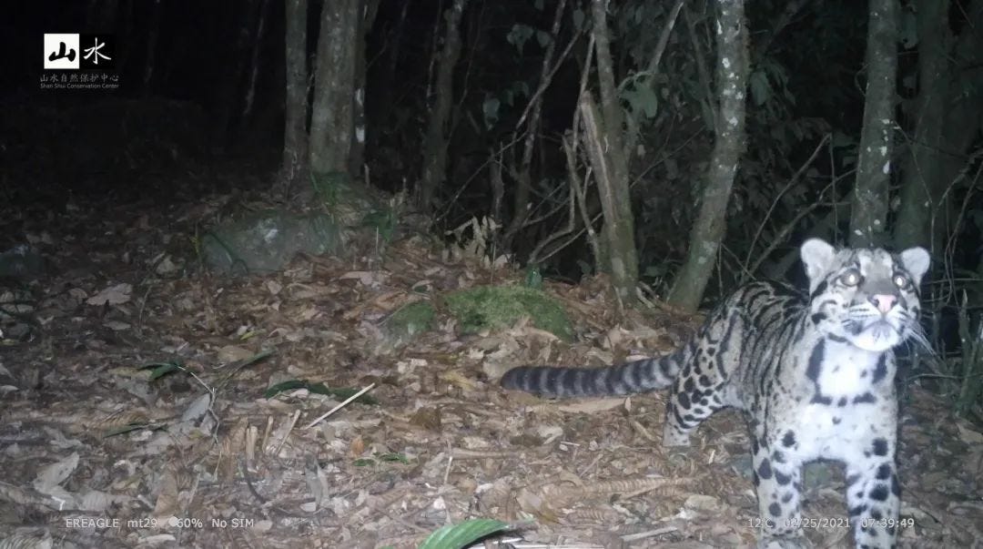
The Chinese Felid Conservation Alliance (CFCA) has written extensively about these issues, warning that the project will cause “habitat loss and fragmentation” in the Great Bend’s forests through construction of tunnels, access roads, and a huge population influx (expected 100,000+ project workers vs. Medog’s 14,934 permanent residents), with “irreversible impacts on the ecology.” They have also expressed concern over the lack of transparency, mentioning they requested to review the EIA and were rejected on the basis that the project is classified as a state secret.
At the upstream Mainling dam, a different challenge is posed by fish. The Yarlung Tsangpo is home to a number of endemic high-altitude fish species - including some nationally protected endangered species - whose life cycles depend on moving up and down the river to reach spawning grounds. Dams interrupt those migrations, forcing developers to find ways to reconnect the habitats.
At the 100m+ Zangmu Dam on the same river higher upstream, engineers were forced to build a ~3.5km fish passage system (a “fish ladder”) to allow native fish to bypass a dam far higher than what fish ladders were traditionally designed to handle.
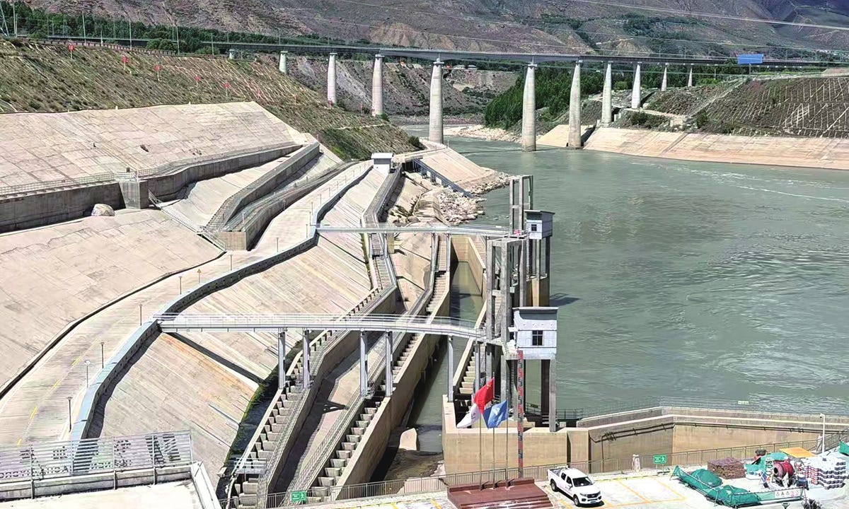
Monitoring data to date suggests fish DO use the facility at the Zangmu dam, and the dam operator has supplemented it with hatchery breeding, fish stocking and other habitat protection program. But fish ladders are ultimately an imperfect solution. The fish can only benefit from the ladder if they finds the entrance, successfully navigate the passage and continue their migration on the other side. The Mainling dam will almost certainly incorporate similar measures, but the long-term question is still unclear as to how effectively they will be at preserving the river’s unique fish populations.
Is the Region Seismically Active?
Yes, extremely. The Yarlung Tsangpo Great Bend sits in one of the most seismically active regions on Earth. The area lies at the collision point of multiple tectonic plates with active faults and rapidly forming/deforming mountains. Since 1900, the Nyingchi region has recorded more than one hundred earthquakes of magnitude 5+, including multiple quakes of M7 or higher. The most catastrophic was the 1950 Assam-Tibet earthquake, which reached M8.7 and remains the largest earthquake ever recorded in China and one of the strongest earthquakes in modern history. More recently, the 2017 Mainling M6.9 earthquake hit directly within the project area, with intensity maps placing Pai Town near the core intensity zone. To put it bluntly, the Yarlung Tsangpo dams and diversion tunnel are being built in an environment where major earthquakes are a predictably recurring geological feature.
Chinese planners are well aware of this problem. The project developed has noted that key project structures are being designed for seismic fortification intensities of 9 to 10 degrees and are expected to withstand earthquakes rated to M8.5. Besides the dams, the project’s underground tunnel system will cross several major fault zones and dozens of subsidiary faults, requiring extensive reinforcement and continuous monitoring. However, the detailed design considerations remain classified, so it is impossible to assess how these risks are being managed.
What Do China’s Downstream Neighbors Think About the Project?
The Yarlung Tsangpo enters India through Arunachal Pradesh, flows across Assam as the Brahmaputra, and then crosses Bangladesh before reaching the Bay of Bengal. Unsurprisingly, the hydropower project has attracted significant attention downstream. The most common concerns include the possibility that China could reduce water flows, manipulate releases for strategic purposes, disrupt ecosystems and sediment transport, or create flood risks. However, many of these concerns are discussed only in generalized and highly politicized terms, making it difficult to distinguish between plausible risks and more broad speculation.
Some concerns appear more credible than others. For instance, claims that China could simply “turn off” the river do not align with the project’s apparent purpose as a hydropower facility, which requires the water to flow, and returns water to the river after generating electricity. But more plausible concerns involve things like coordinating the timing of water flows, since India has its own substantial hydropower ambitions for the river. Bangladesh has also raised questions about sediment transport, as reservoirs are likely to trap some sediment that would otherwise flow downstream. This is important because sediment deposition plays an important role in sustaining the river delta and combating erosion. More broadly, the greatest uncertainty seems to stem not from the project itself, but from the very limited amount of public information available about its design and operation.
Despite the prominence of these concerns in public debate, the official positions of India and Bangladesh have generally been more measured than media coverage might suggest. Bangladesh’s Foreign Adviser Touhid Hossain stated in August 2025 that Bangladesh saw no “reason for concern,” while also pragmatically acknowledging the limits of their influence, remarking: “We cannot stop it… We have to see that we are not harmed.” This pragmatism + caution helps explain Bangladesh’s continued emphasis on transparency and access to hydrological data. India’s official stance has likewise focused primarily on practical issues: obtaining technical information, maintaining dialogue, understanding the project’s engineering details, and ensuring that existing mechanisms for transboundary river cooperation remain functional - not calling for the project to be stopped.
And contrary to some media narratives, there ARE active channels for coordination on these topics between the neighbors. Since 2006, China and India have maintained an Expert Level Mechanism on Trans-Border Rivers, a forum for exchanging hydrological data, discussing flood management and addressing river-related issues like the dam. Both governments continue to reference this channel, and recent reports indicate that meetings and data-sharing arrangements via this mechanism are still active, although some data sharing was suspended in recent years following border tensions in 2022.
To editorialize a bit here the key disagreement may therefore be less about the absence of communication, and more about the format in which it takes place. China traditionally prefers technocratic exchanges conducted via expert and bureaucratic channels, while many Indian politicians, commentators and analysts appear to anticipate a greater degree of public transparency around the project’s design and operation. The challenge for both sides thus would be determining whether a mechanism originally designed for hydrological cooperation like the Expert Level Mechanism on Trans-Border Rivers is a actually sufficient platform for a project of such unprecedented scale. But such matters are probably above my pay grade.
Conclusion (for now)
Well, there we go. All the main FAQs I think there are to know about this controversial and notably mysterious project so far. Hopefully it’s a little less mysterious now than it was before.
I recognize that for large parts of the essay, all I did was replace the speculative OSINT of others with my own, slightly less-speculative OSINT. But at least it’s as up-to-date as possible. And for the other sections, hopefully you’ve found some value in my efforts to summarize what’s up with this project as reasonably as possible. But do let me know if I’ve missed any key FAQs that I could address in future edits.
Thanks for reading!
My take from this well researched article is that it demonstrates the manner in which the PRC has rescued the Tibetan people from feudalism. enabled them to share 21st technology and brought them prosperity. China cares for all its people, including its minorities. Kudos to the author who has shown expertise, diligence, and skill in extensive research and composing a difficult and highly scientific article.