Gansu Travelogue 3: Temples, Horses, and more Temples in Tibetan Gansu

This is Part 3 of my Gansu-Sichuan travel series, retracing my 11-day trip in September 2024 traveling overland from Lanzhou, Gansu to Chengdu, Sichuan. Part 1 is here and Part 2 is here. This long one is more like a classic travel blog than my normal interview content, but I promise I’ll make up for it with some killer interview material next time!
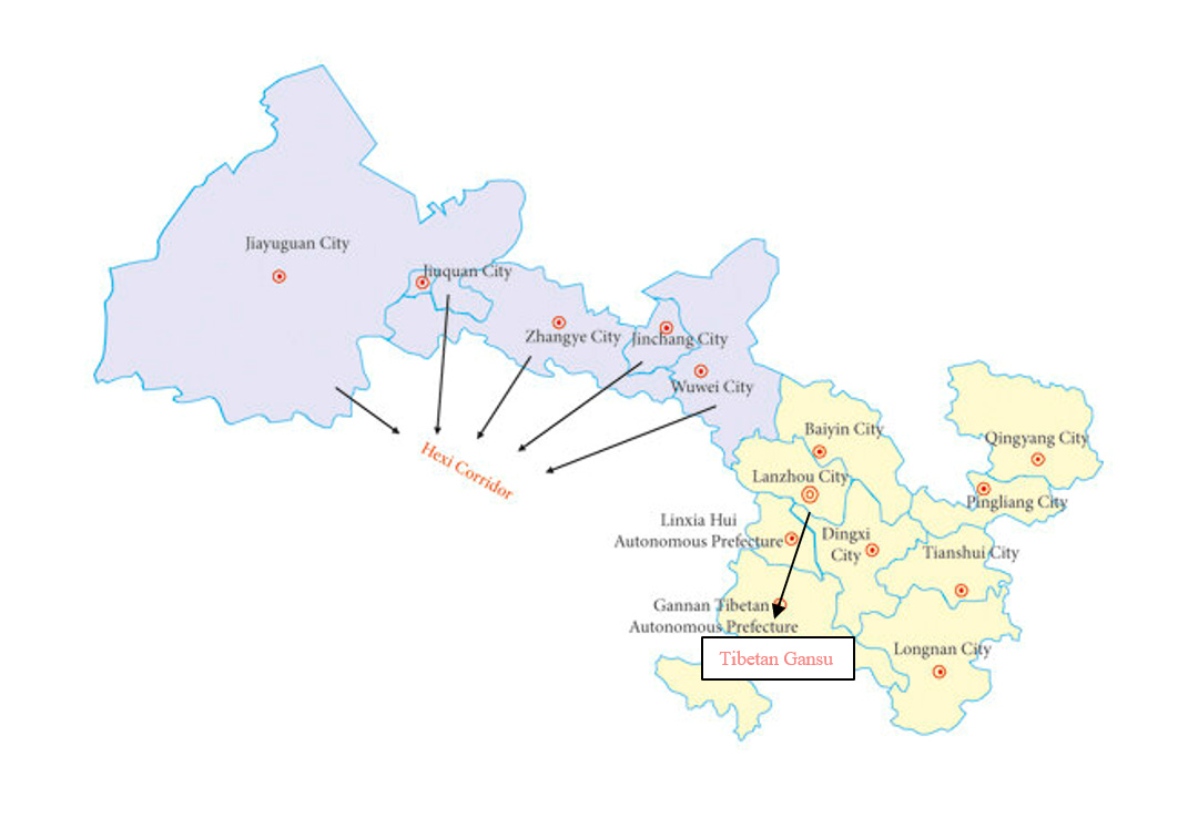
Let’s talk about Gansu Province for a second. Gansu is a long, oddly-shaped province in northwestern China. Those familiar with modern US political districts might even say it looks like it’s been “gerrymandered” into its current shape.

Actually, Gansu’s seemingly odd borders are quite reasonable when you realize they’ve been defined by the natural barriers which encircle the province. The Gobi Desert forms the border with Inner Mongolia to the north; the Kumtag Desert (part of the Taklamakan Desert) forms the border with Xinjiang to the west; the long spine of the Qilian Mountains (a subrange of the Kunlun Mountains) forms the border with Qinghai to the southwest; and the Min Mountains (also a subrange of the Kunlun Mountains) forms the border with Sichuan to the south.
The narrow pass between the Qilian Mountains and the Gobi Desert running down the length of Gansu from northeast-to-southeast is the “Hexi Corridor” (lit. ‘west-of-the-river corridor’, the river in question being the Yellow River) and was a critical path on the ancient Silk Road linking China and Persia.
Tourists looking to explore the ancient desert culture of Gansu’s western regions, including some of the westernmost sections of the Great Wall, will head northwest from the capital Lanzhou up the Hexi Corridor to destinations like Zhangye, Jiuquan, or Jiayuguan (where you can find Dunhuang and its famous Buddhist grottoes). On other other hand, tourists looking to experience Tibetan Gansu can head south from Lanzhou, through Linxia Hui Autonomous Prefecture towards the Gannan Tibetan Autonomous Profecture (T.A.P) on the Sichuan border.
Gannan is the easternmost Tibetan region in China, and also the one with the lowest average elevation, at "only" 3000 meters (9840 feet), a peninsula sandwiched between Qinghai to the west and Sichuan to the south. It’s part of the traditional Tibetan region of Amdo (marked in the blue on the map below). The other 2 traditional Tibetan regions are Kham (in red) and U-Tsang (in brown). These parts of historic Amdo and Kham found across sections of modern-day Qinghai, Sichuan, Gansu, and Yunnan are part of "cultural Tibet" but are outside of the modern borders of the Tibet Autonomous Region.

Amdo today is mostly within modern-day Qinghai (grey-green on the map below) but also covers a bit of Western Sichuan (purple on the map below) and southern Gansu (light blue on the map below)
Kham today is spread across southern Qinghai, western Sichuan, northern Yunnan (dark green below) and eastern parts of the modern-day Tibet Autonomous Region (orange below).
U-Tsang today mostly corresponds to the modern borders of the Tibet Autonomous Region and provides the etymological foundation for the Chinese word for the region, Xizang (西藏).

Non-Chinese will need special passes or are totally blocked from visiting many rural regions of Qinghai, a combination of political sensitivies and security restrictions (Qinghai is full of Chinese military installations). However, the Tibetan regions of Yunnan, Sichuan, and Gansu are generally open for travel (with exceptions e.g., Sertar County in Garze, Sichuan).
After leaving Linxia City (see my last Travelogue), I traveled southwest into Gannan Tibetan Autonomous Prefecture. My planned itinerary included three separate counties within Gannan:
Xiahe County - Labrang Monastery (拉卜楞寺) and Sangkor Grasslands (桑科草原)
Luqu County - Langmu Temple (郎木寺) and Namo Gorge (纳摩峡谷)
Diebu County - Zhakarna (扎尕那) mountain
From Zhakarna, I then planned to leave Gansu and cross into Sichuan to visit the extremely famous Jiuzhaigou Scenic Area.
If you're familiar with this area, you'll see a big part of this trip follows the so-called "Rock's Route" (洛克之路) a trendy sightseeing itinerary through Gansu, Sichuan and Yunnan that has gotten very popular on Chinese social media in recent years. It retraces the 100-year footseps of Joseph Lock, an Austrian-American botanist & explorer who spent 25+ years living in and exploring this region between 1920-1949.

After leaving Linxia and heading southwest, my first stop on on my Gannan tour took me to Xiahe County. In Xiahe, you can find the Sangkor Grasslands and the famous Labrang Monastery, the largest Tibetan Buddhist monastery outside of Tibet proper. Labrang was verboten for non-Chinese tourists to visit for a good few years due to political tensions in the past, but things have relaxed again in recent years and we had no issues when we visited.

Unfortunately, despite its fame, the Labrang Monastery itself was…just ok. It probably would have given me nicer photos if the weather wasn't so rainy. There were many monks around and pilgrims visiting the monastery, but I didn't know what I seeing most of the time. Perhaps I should have gotten an audio guide.

The monastery itself is massive, with many sections off-limits to tourists. I estimate we only walked around 40-50% of the area open to tourists, and that only represented maybe 20% of the monastery.

At least the area around the monastery was mountainous and quite vibey and atmospheric, even in the rain.

Xiahe County seat was quite small and grubby and I didn’t find anyone interesting to chat with while I was there. My main impression of the place is it rained the whole time I was there…and that the drives kept getting interrupted by herds of goats and sheep crossing the road. So I was happy to keep driving onto my next destination: the Sangkor Grasslands.

Unfortunately, the rain persisted through the whole day, which also did the grasslands no justice. I’m sure they would have been much more beautiful in good weather. We saw examples of nomadic herding in the grasslands, which was neat. These herding nomads can move their entire camp within an hour I bet. Grasslands like this are probably the only places in China where you can still observe proper nomadic lifestyles. Besides the occasional tent encampment, most of the grassland comprised rolling green hills like this…and livestock.

The 2hr drive through the Sangkor grasslands brought us through to the Luqu County seat, which was similar to Xiahe County in that it was small, grubby, and entirely uninspiring. Rather than stay here for the night, I elected to keep driving onto Langmu Temple Town, another 1.5 hours away. It was getting dark by this point, so I don’t have much in the way of photos from the drive. The winding steep road was clogged with heavy cargo trucks and really wasn't fun to drive.
Fortunately Langmu Temple would go on to become a highlight of our trip. That night, we checked into a modest but comfortable new hotel owned by a Hui family that kept the place absolutely spotless.

That morning, I watched the grandfather stalking around the lobby, sweeping individual cigarette butts off the sidewalk outside, wiping dust off of house plants, and bending all the way over to glare intently at a tiny speck of dirt on the floor like it had personally offended him before carefully rubbing it away. A perfectionist indeed.

The owner told me they are one of the few Hui families in this Tibetan-majority town, but they are indeed locals. This newly-constructed 4-story hotel replaced their old family guest house that used to stand here. Anyway, I can recommend it completely for any of my followers that ever come this way. The Wifi was good too…I managed to squeeze in a work video call on the rooftop balcony!
Having just come from Linxia, the contrast between the Hui-majority region I had left and the Hui-minority I was in now was striking and obvious. I noticed there's just one mosque in the town - a new one under construction next to the entrance of Langmu Temple (or maybe it was finishing up its renovations). It had the classic Sino-Islamic style that was typical back in Linxia.

I spent the morning hiking around the town and managed to accidentally walk into Sichuan by crossing into the next village over (hah!).

From the back part of the village, I had an eagle’s eye view of the whole town. With some careful finagling of angles, I got this picture of a horse in a field, with an under-construction highway overpass far in the distance. Perhaps future visitors here will have a much easier time with the drive in…

Down in the village itself, things were bustling. Guest houses were under construction everywhere. I caught this Muslim noodle restaurant owner carefully watering his plants with a squirt bottle…

I saw traditional Tibetan houses with brand new SUVs parked out front...

…and monks going to the bank…

The overcast weather cleared up by noon, and it suddenly became the best weather we would see on the whole trip...blue skies and puffy white clouds. Suddenly, the comparisons I had read online to Swiss alpine villages started to make sense…

In the afternoon, we visited the peaceful Langmu Temple and then hiked into the Namo Gorge behind the temple.

In the Namo Gorge, we found a horse camp and decided to go for a horse ride deeper into the valley, without really knowing what we were signing up for…

It turned out to be a 45-minute ride up the valley, along a running creek bed, with our horses led by two Tibetan ladies.

After passing many herds of yak and a few curious marmots, we emerged into a stunning alpine meadow at the base of sheer cliffs. We took dozens of photos of the perfect scenery. Hiking for a minute up to a small outcropping for a better shot, I found myself gasping for air, a sudden reminder we‘re up 3500 meters!

On the way back, I talked with our guides a bit. One barely spoke any Mandarin beyond basic phrases, but the other was chatty. She told me the horses are owned by the villagers and they rent them out as a collective, splitting the profits equally.

She told me because it's the shoulder season (between the summer holiday and the National holiday in October) she'll probably only do this trek once or twice a day. But during the busy season, she'll do 4-5 roundtrips per day to the alpine meadow. Each tourist earns them 300 CNY (45 USD) round-trip. That’s some serious cash in Gansu, one of the poorest provinces in China.
Besides herding yak and some tourism-related services industries, there's little other commerce here. But that's enough. "These yak all belong to her family" she points to our other, relatively mute guide. "We keep yak too, but they're up on the mountain".

"I noticed these all have horns...these are all bulls?" I asked.
"Yes, all bulls. They eat the sweet grass in here, then we eat them."
"So you don't eat the cows?"
"No, cows are more valuable. They give milk, and they give birth to more yak. We mostly eat the males."

"Do you keep the best bulls for breeding? I grew up on a farm too, and we kept sheep and goats, but only ewes. When we wanted to breed them, we paid another farmer to bring his ram over"
"Oh, you pay for a ram? We don't do that here with sheep or yak. But with horses, yes."

It was an amazing experience. Although there were plenty of tourists outside visiting the Langmu Temple, in here we were just about the only people in the deepest part of the valley, on the most gorgeous sunny day of our trip. This was my favorite desination of the entire Gansu portion of the trip.

But, I spent the next three days being sore in body parts I didn't even know I had.

In the early afternoon, we left Langmu Temple Town for our next destination, Zhakarna, but first we we stopped at this roadside coffee van, run by a guy from Chengdu. He told me in a few weeks (after the national holiday) he'll be taking his mobile coffee stand back to Chengdu for the winter.
"There's too much competition in Chengdu. It's lonelier here, but good for business"

When I told him we’re heading for Zhakarna, he wasn’t impressed.
"Oh you're going to Zhakarna? Ugh, I don't like it there. Too much tourism. And the road there is very dangerous...it winds a lot, and it's full of big trucks, and the Tibetan guys drive like maniacs".
I thank him for the coffee and continue to Zhakarna.

The road was indeed a bit sketchy, especially with a few rockfalls along the cliffs, but not as bad as the coffee vendor warned. The grasslands here are stunning in the good weather - it looks like a real-life Windows 98 desktop.

The road actually dips into Sichuna's Zoigê County briefly, then cuts back into Gannan’s Diebu County, passing through several small towns on the roughly 2.5hr drive to Zhakarna.

Zhakarna mountain rises up ahead of the terrain and provides a striking shot as you draw closer. The town nestled at the base of the mountain is cute, and the general environment is truly beautiful, but unfortunately that's the only nice thing I can say about it.

Zhakarna was “discovered” for tourism a few years ago, and I think it’s too late now. The touristy part of the town is truly overdeveloped, the restaurants are meh, and the shopkeepers are pushy. My negative impression of the town was partially mitigated by getting a hotel room with the best view of the trip so far. But overall, I recommend others do it as a day trip only. There’s really no need to spend the night here IMO.

Overally, we were unimpressed by the village at Zhakarna and unwilling to spend extra time here. After a mediocre dinner, we retired to our hotel and were woken up very early the next morning with noise from tourist buses along the main road.
Disappointed with the whole place, I made the decision to spend the day NOT visiting any other sites in Diebu County, and instead drive straight through to Jiuzhaigou in Sichuan. Goodbye Gansu!
For some weird reason (this is foreshadowing) our vehicle’s GPS system refused to identify the road through the mountains that Baidu Maps said existed, and that would get me to Jiuzhaigou in just 5.5 hours. I decided to ignore the car GPS and put my faith in Baidu Maps instead. I had no idea what I was getting myself into.
See you next time…!
